
Glaciers partially cover Iceland with active volcanoes, charming fishing villages, hundreds of waterfalls, inviting fjords, bubbling hot springs, and bustling bars in Reykjavik. The country is full of all these attractions, which are separate fragments in the overall picture of Iceland. Here we look at 15 of the top places we recommend to anyone visit in Iceland. Of course, this is our subjective opinion, but still, let’s explore the best places to visit.
1. The Blue Lagoon
The Blue Lagoon is one of Iceland’s most popular attractions and no wonder why. The beautiful milky turquoise water is unlike anything else, and the lagoon itself is in stark contrast to the surrounding black lava fields covered with moss. The water temperature in the lagoon is 38°C (100°F) all year round, making the place ideal for bathing. The lagoon is located on the Reykjanes Peninsula in southwestern Iceland, known for its barren landscapes and cone-shaped volcanoes. It is just 15 minutes from Keflavik International Airport and about 45 minutes from Reykjavik city center. That makes the lagoon ideal as the first stop in Iceland after arrival at the airport or the last stop before leaving the country.
With its prime location, soothing waters, and skin-healing minerals, the Blue Lagoon has become Iceland’s most visited attraction, second only to a sightseeing tour of the Golden Circle. Please remember that you might need to book an entrance several days or even weeks in advance to get to the lagoon.
2. Gullfoss Waterfall / Golden Circle
According to the World of Waterfalls, Gullfoss Waterfall is one of the ten best waterfalls globally. The waterfall forms on the cascades of the Hvita (White River) River, which originates from the Langjökull Glacier (Long Glacier), giving Gullfoss a stunning flow and beautiful watercolor. The falls form two cascades 33 meters / 100 feet high, and then the river flows through a rugged canyon up to 70 meters high. In summer, when the meltwater flow from Langjökull is particularly high, the Hvita River brings an average of 140 cubic meters of water per second.
This waterfall holds an essential place in the hearts of most Icelanders. The possibility of using the enormous potential of the river to generate hydropower at the beginning of the last century created a kind of bipolarity between those who wanted to build a power plant on this site and those who wanted to preserve the waterfall. There is a local legend about how the daughter of a farmer, one of the owners of the waterfall, saved Gullfoss from destruction. Iceland has taller waterfalls, but the chance to see the full power and grandeur of Gullfoss is a must-see for yourself.
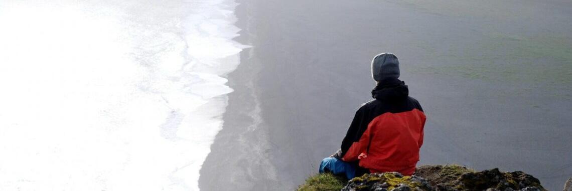
3. Reynisfjara Black Sand Beach / South Coast
If you’ve heard of Iceland’s famous black sand beaches, you’ve probably heard of Reynisfjára (Rainier Beach). Reynisfjára is located on the South Coast and can be found just before reaching Vik if you come from Reykjavik. This stunning place is known for its exciting geology: a black sand beach, basalt columns Halsanef, and Reynisdrangar rock stacks at sea opposite the beach, and for local folklore.
Legend has it that the rock stacks are two Icelandic trolls who once tried to drag a ship from sea to land at night time. They could not get on the boat until sunrise, and both trolls and ship turned to stone at the first rays of the sun. Believe it or not, this is another unique natural formation even for Iceland. Getting to the black sand beach is easy enough, but when visiting Reynisfjara, please be aware of strong waves, especially during high tide.
4. Skogafoss Waterfall / South Coast
Skogafoss (Forest Waterfall), located on the Skogá river near the small village of Skógar, is one of the largest in Iceland, with a height of about 60m / 190feet and a width of 25m / 75feet. It is unique in that the waterfall originates directly from two glaciers: Eyjafjallajökull and Myrdalsjökull. Due to a large fog in the waterfall footage, one or even two rainbows can be seen on a sunny day.
You can get close to the waterfall at its base to take a photo with the rainbow in the background, but try not to get wet in the mist from the spray. There is an observation deck at the top of the waterfall with stunning views. Although not everyone can climb the steep stairs to the observation deck, the views from there are impressive and are a great way to get a bird’s eye view of the area. At the top, you will see the river that feeds the waterfall and the start of the popular Fimmvörðuháls hiking trail to the Þórsmörk Valley. The waterfall is about two hours from Reykjavik, next to the ring road, and is a must-see for anyone traveling along Iceland’s South Coast.
5. Dyrholaey South Cape / South Coast
Dyrhólaey is a beautiful promontory on the south coast of Iceland. You can enjoy stunning views of the lighthouse at the clifftop, surrounding black beaches on the west and east sides, massive Eyjafjallajökull and Myrdalsjökull glaciers from the north, and the Atlantic Ocean from the south. Dyrhólaey south cape is a massive rock 120 meters high. A part of the rock is the southernmost point of Iceland. A narrow 100-meter spur of the rock stretches south into the Atlantic Ocean with sheer cliffs on either side. Seen from the side, you will see a large arched hole in the rock of the promontory. This hole gives the cape the name Dyrhólaey (Door Hole Island).
Dyrhólaey has a volcanic origin and was formed during the last ice age due to an underwater eruption. It is believed to be about 80 thousand years old. An “island” or small peninsula is often divided into two parts, south and west, because it comprises two different types of rocks: basalt and tuff. Dyrhólaey is one of the best spots in Iceland to see puffins (May to August).
6. Arnarstapi Fishing Village / Snæfellsnes Peninsula
Arnarstapi (Arnar’s Cape) is a fishing village located a 2-hour drive from Reykjavik at the footage of Stapafel mountain on the southern side of the Snaefellsnes Peninsula. It was an important trading post in the past, and its population was much larger than it is now. The cliffs along the coastline are home to myriads of birds, mochas, fulmars, razors, and many others that nest in the area. There is a relatively large colony of Arctic terns in the village itself. Walking along the coast for bird watching and magnificent lava formations are recommended. On the way, three gorges open up, connected with the sea. When a strong south wind blows, they create fountains of ocean water, and then it is not recommended to stand too close.
In recent years, the small village of Arnarstapi can get quite busy during the summer, with tourists coming to experience the atmosphere of an authentic small fishing village. Those interested in fresh food come for fish caught near the beach and photographers for incredible opportunities for photographing birds and landscapes. A fascinating old trail runs along the coastline where you can see old fishers landing sites, many birds and walk through a lava field. A sculpture of the legend of this area, Bardur Snaefellsas, a half-human, half-troll, stands on the beach in Arnarstapi.
7. Lóndrangar Cliffs / Snæfellsnes Peninsula
Lóndrangar is a stunning rock formation in the southern part of the Snæfellsnes peninsula, near Hellnar. Two large rock stacks with a height of 75 meters and 61 meters towering on the ocean at the foot of the Snafellsjokul volcano are Lóndrangar. These two towers are considered the old plug of the volcano, which has resisted the forces of nature for tens of thousands of years. They have withstood the wind, the powers of the ocean, and even the eruptions that pushed even more lava around them thousands of years ago. This place has fascinated Icelanders for centuries and was considered mysterious.
Today, the pillars are mainly home to many species of birds and are pleasant to look at from all angles. There is a car park by the road with a trail to the observation deck on the east side of Lóndrangar, from where you can see the majestic cliffs and rocky coast. If you want to see everything up close, the best option is to drive to a lighthouse at Malarrif. A relatively easy walking trail runs from the lighthouse to Londrangar. It is a pleasant stroll through the scenic area where you can feel the power of the ocean if the wind blows. Standing there, looking at this stunning nature with a glacier behind us and feeling the power of the sea, is entirely different.
8. Myrdalsjokull Glacier / South Coast
Myrdalsjökull is a glacier in the south of the Icelandic Highlands. It is the fourth largest ice cap in the country, covering nearly 600 sq. km (232 sq. mi) and its highest peak at an elevation of almost 1,500 m. The glacier is best known for being at the top of the infamous and explosive Katla Volcano.
Myrdalsjökull is visible from the Ring Road on the South Coast, north of the village of Vik. It is visited for snowmobiling, ice caves, and helicopter tours. One of its glacier tongues, called Sólheimajökull, is its most famous glacier hikes and ice climbing destination. One-day excursions to the South Coast will introduce you to this glacier. You can get to Sólheimajökull by driving to the car parking, just 4 kilometers from the Ring Road, and walking about half an hour along the trail towards the glacier.
9. Landmannalaugar / Central Highlands
Landmannalaugar is a natural wonder, an area of colorful rhyolite mountains in the Fjallabak Nature Reserve. It sits on the edge of the Laugahraun lava field formed during an eruption in the 15th century. Landmannalaugar is known for its natural geothermal hot springs and surrounding landscape, vibrant peaks, steam plumes, and clear blue lakes. Landmannalaugar means “pools of people,” named after the unique hot spring pools that have warmed Icelanders for centuries. Arriving in the area, you will see colorful mountains ranging from green to blue to black, yellow, and even pink. These colors are completely natural – the result of local geothermal activity. A journey through the other world is a test of the vast expanses of this magnificent place.
The most famous attractions in the area are the Brennisteinsalda and Blanjukur mountains, their natural hot pools, and the Laugagraun lava field. Additional nearby attractions include the ironically named Ljótpollur (“Ugly Puddle”) and the charming Frostastadavatn Lake. Trips to Landmannalugar are possible during the summer season from June to September.
10. Reykjavik / Capital Region
Reykjavik is the capital of Iceland, the northernmost capital in the world, and a small city with an excellent reputation. Get ready to admire colorful houses, local museums, and vibrant nightlife. Reykjavik is also a great base for day trips from the city along the most popular routes to discover Iceland’s natural wonders.
Nearly two-thirds of the country’s population lives in Reykjavik and the suburbs. Of course, this is only about 200 thousand people, but the city’s charm compensates what it lacks in terms of population. Reykjavik is a vibrant cultural and design life, with plenty of city tours, vibrant nightlife, modern museums, great restaurants, galleries, shops, bars, and clubs to explore during your stay. Iceland’s capital is also a great base from which to explore some of the island’s stunningly beautiful natural wonders, such as the famous Blue Lagoon geothermal resort, the Northern Lights, or the Golden Circle, where you’ll see raging geysers, waterfalls, rift valleys and more. Whichever way you choose to spend your time in Reykjavik, this is a truly unique journey through the city.
11. Jökulsarlón Glacier Lagoon / South-East Iceland
Jokulsarlon is a large glacial lake or lagoon on the southeast coast. It is one of the most popular tourist attractions in Iceland. The lagoon is located next to the Ring Road between Skaftafell park and Hofn town. Jokulsarlón is usually full of icebergs that have broken away from the sizeable Breidarmerkurjokull glacier tongue, part of the Vatnajokull glacier, the largest ice cap in Europe. The charm of the lagoon in the floating icebergs of various shapes, sizes, and shades of ice from white to blue. Although many glaciers are retreating due to global warming, Breidamerkurjökull is retreating faster than others. The lagoon is expanding as saltwater from the ocean makes its way into the lagoon during high tides.
Between May and October, you can take an amphibious boat or Zodiac speed boat ride through the lagoon to get closer to floating icebergs and the base of a glacier descending into the lagoon. During wintertime, you can take an ice cave tour provided by local operators. And after you’re done enjoying the lagoon, you can also visit Diamond Beach from the ocean side, where large chunks of ice are swept out of the lagoon and then washed by ocean waves to the shore of black sand.
12. Asbyrgi Canyon / North-East Iceland
Ásbyrgi Canyon in northeastern Iceland is a horseshoe-shaped glacial depression with sheer cliffs up to 100 meters high. It is 3.5 km long and over 1 km wide. On its inner side is the small Botnstjörn pond surrounded by lush vegetation. In the center of Ásbyrgi, a characteristic rock formation, Eyjan rises to 250 m wide.
The canyon territory is covered with forest, consisting mainly of birch, willow, rowan, and planted pines.
Asbyrgi was formed by two or more catastrophic floods caused by glaciers in the northern part of the Vatnajökull ice cap, from eight to ten thousand years ago and about three thousand years ago. One of the local legends associated with this place says that Sleipnir, the eight-legged horse of the god Odin, stepped one of his hooves to the ground when the god flew by and a canyon appeared at this place. Since then, the river bed, which eroded the canyon, has moved to the east. You can visit Ásbyrgi as one of the highlights of the Diamond Circle tour from Akureyri.
13. Lake Myvatn / North-East Iceland
Myvatn is a beautiful lake in the north of Iceland. The volcanic landscape of this region is dominated by pseudocraters formed by an eruption about 2,300 years ago. Lake Myvatn and its surroundings, often called the Myvatn geothermal zone, are part of the Diamond Circle in northeastern Iceland. Idyllic blue lakes and hot pools, sandy mountains, volcanic craters, and colorful mud pools make up the most incredible place, and many describe the area as otherworldly.
This part of Iceland is fascinating with geothermal energy, and there are clear signs of volcanic activity on earth that have occurred there in recent centuries. The colors in this area are in stark contrast to the pitch-black lava fields and mountains around. The rhyolite red and purple mud pools in Namaskard and the azure blue waters of Lake Myvatn are mesmerizing and seem to have come from nowhere to the mysterious land of Myvatn.
14. The Westfjords / North-West Iceland
Westfjords is a stunning and remote part of Iceland. While the rest of Iceland is full of tourists, the Westfjords are much less visited. Westfjords are the oldest part of Iceland and are believed to have formed due to eruptions that took place about 16 million years ago. Ice ages and glaciers have carved mountains and fjords, resulting in their unique and sharp edges and shape. The charming farm fjords here are grand for outdoor activities. The Westfjords have Iceland’s best hiking trails, some of the most stunning kayaking fjords, and the most magical hot pools. Even if you have been in Iceland before or have driven through the Eastfjords on the ring road, traveling through the Westfjords of Iceland is a completely different experience.
15. Thingvellir National Park / Golden Circle
Thingvellir National Park is famous both historically and geologically. The Mid-Atlantic Ridge runs through Iceland, dividing the country into two parts belonging to the American and Eurasian tectonic plates. Thingvellir is part of the fracture zone at the border of tectonic plates. The Thingvellir Valley is home to Iceland’s largest lake, Thingvallavatn.
The fissures are the main feature of the Thingvellir landscape; the largest of them, Almannagjá, forms a rock wall and is the backdrop for the old meeting place.
Thingvellir is also the cradle of democracy in Iceland and the Althingi parliament, founded around 930 and serving as a general parliamentary assembly until 1798. At the time of the meetings, Thingvellir acted as the first capital of Iceland for two weeks each year. Its dramatic story since the founding of Althingi provides an insight into how the first settlers of Iceland during the Viking Age organized their society from scratch and evolved towards the modern world. Althingi performed his duties at Logberg (Law Rock) in Thingvellir, where most performances occurred.